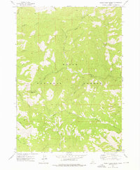
1972 Map of Rabbit Creek Summit
USGS Topo · Published 1976About this map
Boise National Forest encompasses this wilderness area where the Rabbit Creek Summit divides a complex network of high-elevation drainages. In the early 1970s, the terrain was navigated primarily through remote routes like the Pack Trail and Pack Tr, which provided access to deep valleys and ridges. The drainage system is anchored by Rabbit Creek, which branches into its North Fork and South Fork, while Meadow Creek and French Creek drain the southern portions of the quadrangle. The map captures a moment when human infrastructure was minimal, noted only by a lone Footbridge over the water. This survey is an essential record of the Boise and Elmore county line before modern development or forest management altered the primitive access routes through the Idaho backcountry.
Find a feature on this map
24 named features on this map. Tap any name to fly to it.
Don’t see what you’re looking for? This feature index may not catch every label — zoom into the map to look around manually.
Map Details
Editions of this 1972 Rabbit Creek Summit Map
This is the sole edition of this map. No revisions or reprints were ever made.
Other maps of this area

1894 · Idaho Basin
USGS Topo · 1:125,000

1955 · Hailey
USGS Topo · 1:250,000

1957 · Pioneerville
USGS Topo · 1:24,000

1957 · Idaho City
USGS Topo · 1:24,000

1959 · Hailey
USGS Topo · 1:250,000

1962 · Hailey
USGS Topo · 1:250,000

1964 · Sheep Creek
USGS Topo · 1:24,000

1964 · Twin Springs
USGS Topo · 1:24,000
1969 · Arrowrock Reservoir NE
USGS Topo · 1:24,000
1972 · Barber Flat
USGS Topo · 1:24,000