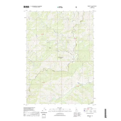
2020 Map of Barber Flat
USGS Topo · Published 2020About this map
Boise National Forest contains the meeting point of the North Fork Boise River and the Middle Fork Boise River, forming a complex drainage system within the Boise Mountains. This 2020 survey illustrates the remote topography of the Boise and Elmore County line, where human settlement is concentrated at Barber Flat and Alexander Flats. The historical Atlanta Road provides the primary access along the southern watercourse, passing through the Alexander Plantation and Dobson Gulch. High-elevation landmarks such as Hungarian Ridge and Hungarian Summit dominate the western portion of the sheet, while numerous named tributaries like Crooked River and Lost Creek carve out a series of ridges, including Lost Creek Ridge. The map details a network of forest service spurs, such as the Barber Flat Spur, that reflect contemporary land management and recreational access in this steep mountain landscape.
Find a feature on this map
54 named features on this map. Tap any name to fly to it.
Don’t see what you’re looking for? This feature index may not catch every label — zoom into the map to look around manually.
Map Details
Editions of this 2020 Barber Flat Map
This is the sole edition of this map. No revisions or reprints were ever made.
Other maps of this area

1894 · Idaho Basin
USGS Topo · 1:125,000

1894 · Rocky Bar
USGS Topo · 1:125,000

1955 · Hailey
USGS Topo · 1:250,000

1959 · Hailey
USGS Topo · 1:250,000

1962 · Hailey
USGS Topo · 1:250,000

1964 · Little Trinity Lake
USGS Topo · 1:24,000

1964 · Sheep Creek
USGS Topo · 1:24,000

1964 · Twin Springs
USGS Topo · 1:24,000
1972 · Rabbit Creek Summit
USGS Topo · 1:24,000
1972 · Barber Flat
USGS Topo · 1:24,000