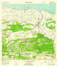
1957 Map of Barceloneta
USGS Topo · Published 1961About this map
Central Plazuela stands as a focal point of the northern coastal plains, illustrating the industrial landscape of the late 1950s near the mouth of the Río Grande de Manatí. This survey captures a transitional period in Puerto Rico's history, where agriculture and sugar production remained central to the local economy alongside the rising importance of transportation routes. The landscape transitions from the coastal lowlands of Palmas Altas and the wetlands of Ciénaga Tiburones to the distinctive karst topography of the interior.
Find a feature on this map
61 named features on this map. Tap any name to fly to it.
Don’t see what you’re looking for? This feature index may not catch every label — zoom into the map to look around manually.
Map Details
Editions of this 1957 Barceloneta Map
This is the sole edition of this map. No revisions or reprints were ever made.
Other maps of this area

1942 · Manati
USGS Topo · 1:30,000

1942 · Arecibo
USGS Topo · 1:30,000

1942 · Barceloneta
USGS Topo · 1:30,000

1943 · Utuado NE
USGS Topo · 1:10,000

1946 · Barceloneta
USGS Topo · 1:30,000

1946 · Utuado
USGS Topo · 1:30,000

1946 · Ciales
USGS Topo · 1:30,000

1946 · Arecibo
USGS Topo · 1:30,000

1946 · Florida
USGS Topo · 1:30,000

1946 · Manati
USGS Topo · 1:30,000
Featured Places
- Barceloneta, Barceloneta
- Allende, Arecibo
- Asomante, Arecibo
- La Romana, Arecibo
- San Francisco, Barceloneta