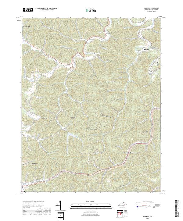
2022 Map of Barcreek
USGS Topo · Published 2022About this map
Goose Creek and its many winding tributaries define this portion of Clay County, where steep hollows and narrow gaps dictate the pattern of human settlement. Small communities like Tanksley, Hector, and Spurlock are situated along the valley floors, connected by routes like State Hwy 149 Hector Rd and the Hal Rogers Pky. The terrain is characterized by numerous named gaps, such as Maupin Gap and Mountain Spring Gap, which historically served as vital passage points through the dense ridges of the Cumberland Plateau. Genealogy researchers may find particular value in the Lincoln Gilbert Cem located near the Red Bird River. The landscape is a complex network of family-named landmarks and watercourses, including Mill Pond Hollow and Big Graveyard Hollow, reflecting generations of local history in the Appalachian highlands.
Find a feature on this map
86 named features on this map. Tap any name to fly to it.
Don’t see what you’re looking for? This feature index may not catch every label — zoom into the map to look around manually.
Map Details
Editions of this 2022 Barcreek Map
This is the sole edition of this map. No revisions or reprints were ever made.
Other maps of this area

1891 · Manchester
USGS Topo · 1:125,000

1952 · Hima
USGS Topo · 1:24,000

1952 · Manchester
USGS Topo · 1:24,000

1953 · Oneida
USGS Topo · 1:24,000

1953 · Big Creek
USGS Topo · 1:24,000

1953 · Mistletoe
USGS Topo · 1:24,000

1954 · Barcreek
USGS Topo · 1:24,000

1954 · Maulden
USGS Topo · 1:24,000
1954 · Ogle
USGS Topo · 1:24,000
1954 · Creekville
USGS Topo · 1:24,000