
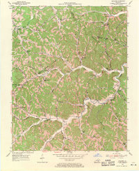
1954 Map of Maulden
USGS Topo · Published 1955About this map
Sturgeon Creek and Sexton Creek carve deep valleys through this part of the Cumberland Plateau during the mid-1950s, defining a landscape of isolated ridges and hollows where the Jackson, Owsley, and Clay County lines meet. The settlement pattern is strictly dictated by the water, with small communities like Maulden and Island City clinging to the narrow fertile bottomlands. These areas are anchored by essential community structures such as the Mt Gilead Ch and Island City Ch, alongside small rural education centers like the Maulden Sch and Buncomb Sch.
Find a feature on this map
78 named features on this map. Tap any name to fly to it.
Don’t see what you’re looking for? This feature index may not catch every label — zoom into the map to look around manually.
Map Details
Editions of this 1954 Maulden Map
2 editions found
Other maps of this area

1891 · Manchester
USGS Topo · 1:125,000

1952 · Portersburg
USGS Topo · 1:24,000

1952 · Manchester
USGS Topo · 1:24,000

1953 · Mc Kee
USGS Topo · 1:24,000

1953 · Oneida
USGS Topo · 1:24,000

1953 · Tyner
USGS Topo · 1:24,000

1953 · Booneville
USGS Topo · 1:24,000

1953 · Sturgeon
USGS Topo · 1:24,000

1954 · Barcreek
USGS Topo · 1:24,000

1957 · Jenkins
USGS Topo · 1:250,000