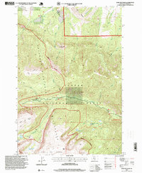
1996 Map of Bare Mountain
USGS Topo · Published 1999About this map
Absaroka Beartooth Mountains dominate this high-altitude terrain, where the peaks of Bare Mountain and Burnt Mountain rise above the drainage basins of the Custer National Forest. This 1990s landscape is defined by its transition from the steep canyon of West Fork Rock Creek to the expansive, glaciated tableland of the Silver Run Plateau. The map highlights a network of back-country infrastructure, including Camp Senia and several remote alpine water bodies such as Lake Gertrude, Silver Run Lakes, and Basin Creek Lake.
Find a feature on this map
32 named features on this map. Tap any name to fly to it.
Don’t see what you’re looking for? This feature index may not catch every label — zoom into the map to look around manually.
Map Details
Editions of this 1996 Bare Mountain Map
This is the sole edition of this map. No revisions or reprints were ever made.
Other maps of this area

1898 · Granite Mountain District
USGS Topo · 1:125,000

1932 · Red Lodge No 2
USGS Topo · 1:48,000

1932 · Nye No 1
USGS Topo · 1:48,000

1954 · Billings
USGS Topo · 1:250,000

1956 · Roscoe
USGS Topo · 1:24,000

1956 · Alpine
USGS Topo · 1:62,500

1956 · Mackay Ranch
USGS Topo · 1:24,000

1956 · Mount Maurice
USGS Topo · 1:62,500

1956 · Castagne
USGS Topo · 1:24,000

1957 · Billings
USGS Topo · 1:250,000