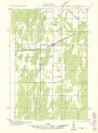
1932 Map of Bark River NE
USGS Topo · Published 1932About this map
Bark River and the neighboring settlement of Harris serve as the primary hubs of this 1932 Upper Peninsula survey, situated along the vital Chicago and Northwestern rail line and state highway. This advance sheet, compiled from early aerial photography, reveals a landscape defined by its rural infrastructure and drainage. The township boundaries of Bark River, Harris, and Gourley divide the territory, which is dotted with essential local landmarks like the Sunnyside Sch and Riverside Sch.
Find a feature on this map
20 named features on this map. Tap any name to fly to it.
Don’t see what you’re looking for? This feature index may not catch every label — zoom into the map to look around manually.
Map Details
Editions of this 1932 Bark River NE Map
2 editions found
Other maps of this area

1932 · Bark River NE
USGS Topo · 1:31,680

1932 · Whitney SE
USGS Topo · 1:31,680

1932 · Gladstone SW
USGS Topo · 1:31,680

1954 · Escanaba
USGS Topo · 1:250,000

1957 · Escanaba
USGS Topo · 1:250,000

1958 · Escanaba
USGS Topo · 1:250,000

1958 · Gladstone
USGS Topo · 1:62,500

1958 · Escanaba
USGS Topo · 1:62,500

1963 · Bark River
USGS Topo · 1:62,500

1963 · Schaffer
USGS Topo · 1:62,500