
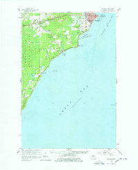
1958 Map of Escanaba
USGS Topo · Published 1959About this map
The city of Escanaba serves as the industrial and maritime anchor of this mid-century Upper Peninsula landscape, situated where Little Bay de Noc meets the wider Green Bay. The urban grid transitions quickly into the timbered reaches of the Menominee State Forest and the fertile lowlands along the Ford River. Transportation infrastructure is central to the area's identity, featuring the Chicago and North Western railway lines and the Escanaba Airport. Rural life is marked by small settlements like Narenta and Pine Ridge, alongside community cornerstones such as Bonifas Chapel and the Ford River School. Maritimers and historians can trace navigational landmarks including the Sand Point Light and Portage Point, while genealogists will find several burial grounds, including Holy Cross Cemetery and the West Ford River Cemetery.
Find a feature on this map
41 named features on this map. Tap any name to fly to it.
Don’t see what you’re looking for? This feature index may not catch every label — zoom into the map to look around manually.
Map Details
Editions of this 1958 Escanaba Map
2 editions found
Other maps of this area

1932 · Gladstone SE
USGS Topo · 1:31,680

1932 · Bark River NE
USGS Topo · 1:31,680

1932 · Whitney SE
USGS Topo · 1:31,680

1932 · Rapid River SW
USGS Topo · 1:31,680

1932 · Gladstone SW
USGS Topo · 1:31,680

1954 · Escanaba
USGS Topo · 1:250,000

1957 · Escanaba
USGS Topo · 1:250,000

1958 · Escanaba
USGS Topo · 1:250,000

1958 · Gladstone
USGS Topo · 1:62,500

1958 · Peninsula Point
USGS Topo · 1:62,500