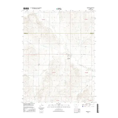
2015 Map of Barnard
USGS Topo · Published 2015About this map
The town of Barnard serves as the central hub of this north-central Kansas landscape, situated where the high plains begin to break into a dense network of creek drainages. The topography is defined by the convergence of several major waterways, including Salt Cr, Rattlesnake Cr, and the branching headwaters of W Elkhorn Cr. This hydrological pattern historically dictated the placement of rural infrastructure and the dispersal of early settlements.
Find a feature on this map
38 named features on this map. Tap any name to fly to it.
Don’t see what you’re looking for? This feature index may not catch every label — zoom into the map to look around manually.
Map Details
Editions of this 2015 Barnard Map
This is the sole edition of this map. No revisions or reprints were ever made.
Other maps of this area

1892 · Minneapolis
USGS Topo · 1:125,000

1894 · Beloit
USGS Topo · 1:125,000

1952 · Glasco SW
USGS Topo · 1:24,000

1955 · Manhattan
USGS Topo · 1:250,000

1955 · Beloit
USGS Topo · 1:250,000

1956 · Manhattan
USGS Topo · 1:250,000

1957 · Manhattan
USGS Topo · 1:250,000

1959 · Beloit
USGS Topo · 1:250,000

1962 · Lincoln
USGS Topo · 1:24,000
1963 · Shady Bend
USGS Topo · 1:24,000