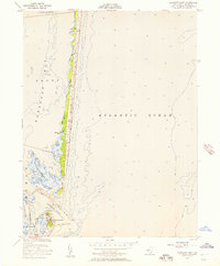
1953 Map of Barnegat Light
USGS Topo · Published 1957About this map
Island Beach stretches as a narrow barrier between the Atlantic Ocean and the intricate marshlands of Barnegat Bay in this mid-century coastal study. At the southern tip, the iconic Lighthouse and the settlement of Barnegat Light anchor the landscape, protected by a prominent Rock Jetty at the mouth of the Barnegat Inlet. The map reveals a complex aquatic environment where the Sedge Islands fragment the bay into shallow passages and small coves like Johnny Allens Cove. These surveys, compiled by the Coast and Geodetic Survey from 1951 aerial photography and field checks, document the shifting sands and hydrography of the Jersey Shore during a period of steady maritime activity. Nautical details such as Tices Shoal and a designated Cable Area underscore the area's significance for local navigation and communication infrastructure.
Find a feature on this map
17 named features on this map. Tap any name to fly to it.
Don’t see what you’re looking for? This feature index may not catch every label — zoom into the map to look around manually.
Map Details
Editions of this 1953 Barnegat Light Map
3 editions found
Other maps of this area

1888 · Barnegat
USGS Topo · 1:62,500

1888 · Long Beach
USGS Topo · 1:62,500

1893 · Long Beach
USGS Topo · 1:62,500

1893 · Barnegat
USGS Topo · 1:62,500

1898 · Barnegat
USGS Topo · 1:62,500

1919 · Long Beach
USGS Topo · 1:62,500

1919 · Barnegat
USGS Topo · 1:62,500

1941 · Toms River
USGS Topo · 1:62,500
1941 · Long Beach
USGS Topo · 1:62,500

1946 · Wilmington
USGS Topo · 1:250,000