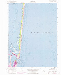
1953 Map of Barnegat Light
USGS Topo · Published 1973About this map
Barnegat Light stands at the northern tip of Long Beach, marking the critical junction between the Atlantic Ocean and the navigational waters of Barnegat Inlet. This mid-century survey, updated with 1970s aerial data, shows the concentrated settlement around the historic Lighthouse and its accompanying Flagtower. Across the inlet, the southern reaches of Island Beach State Park remain largely undeveloped, characterized by a thin ribbon of dunes separating the ocean from the marshy Sedge Islands and Johnny Allens Cove. The map documents the protective maritime infrastructure of the era, including the prominent Rock Jetty and the Boat Basin, which supported the local fishing and recreational boating economy within Barnegat Bay.
Find a feature on this map
19 named features on this map. Tap any name to fly to it.
Don’t see what you’re looking for? This feature index may not catch every label — zoom into the map to look around manually.
Map Details
Editions of this 1953 Barnegat Light Map
3 editions found
Other maps of this area

1888 · Barnegat
USGS Topo · 1:62,500

1888 · Long Beach
USGS Topo · 1:62,500

1893 · Long Beach
USGS Topo · 1:62,500

1893 · Barnegat
USGS Topo · 1:62,500

1898 · Barnegat
USGS Topo · 1:62,500

1919 · Long Beach
USGS Topo · 1:62,500

1919 · Barnegat
USGS Topo · 1:62,500

1941 · Toms River
USGS Topo · 1:62,500
1941 · Long Beach
USGS Topo · 1:62,500

1946 · Wilmington
USGS Topo · 1:250,000