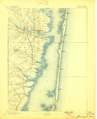
1893 Map of Barnegat
USGS Topo · Published 1898About this map
Barnegat Light stands at the southern edge of this late 19th-century survey, marking the vital inlet where the Atlantic Ocean meets the interior waters. The barrier island is punctuated by a series of Life Saving Stations, including L.S. Station Toms River and L.S. Station Island Beach, reflecting the era's reliance on shore-based maritime safety. Inland, the landscape is defined by the intersection of rail and river, as the Philadelphia and Long Branch Railroad (Penn R.R.) crosses Barnegat Bay to reach coastal settlements like Lavallette and Seaside Park. To the west, the winding paths of Toms River and Cedar Creek lead into timbered areas and small outposts like Double Trouble, illustrating the early industrial character of the Pine Barrens before its modern residential expansion.
Find a feature on this map
47 named features on this map. Tap any name to fly to it.
Don’t see what you’re looking for? This feature index may not catch every label — zoom into the map to look around manually.
Map Details
Editions of this 1893 Barnegat Map
2 editions found

Other maps of this area

1884 · Whitings
USGS Topo · 1:62,500

1888 · Barnegat
USGS Topo · 1:62,500

1888 · Little Egg Harbor
USGS Topo · 1:62,500

1888 · Asbury Park
USGS Topo · 1:62,500

1888 · Cassville
USGS Topo · 1:62,500

1888 · Long Beach
USGS Topo · 1:62,500

1888 · Whitings
USGS Topo · 1:62,500

1893 · Little Egg Harbor
USGS Topo · 1:62,500

1893 · Asbury Park
USGS Topo · 1:62,500

1893 · Long Beach
USGS Topo · 1:62,500