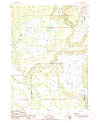
1988 Map of Barnes Valley
USGS Topo · Published 1988About this map
The high plateau and drainage basins of the Fremont National Forest are captured here in the late 1980s, revealing a landscape defined by ranching and water management. The terrain is characterized by broad flats and valleys, most notably Barnes Valley and the expansive Squaw Flat. Evidence of livestock operations and early land use is present at Simmons Ranch and DeVaul Ranch, both situated near the Klamath and Lake County boundary. The hydrology of the area is heavily modified with human-made structures including the Lower Fishhole Levee and several catchments such as Little Squaw Flat Reservoir and Tull Reservoir. These features, alongside numerous springs and the flow of Fishhole Creek, illustrate the vital importance of water control in this part of Oregon. From the heights of Juniper Mountain to the depressions of Strawberry Flat, the map documents the geographic intersection of natural timberlands and high-desert basin ranching.
Find a feature on this map
25 named features on this map. Tap any name to fly to it.
Don’t see what you’re looking for? This feature index may not catch every label — zoom into the map to look around manually.
Map Details
Editions of this 1988 Barnes Valley Map
This is the sole edition of this map. No revisions or reprints were ever made.
Other maps of this area

1889 · Klamath
USGS Topo · 1:250,000

1894 · Klamath
USGS Topo · 1:250,000

1955 · Klamath Falls
USGS Topo · 1:250,000

1958 · Klamath Falls
USGS Topo · 1:250,000

1960 · Gerber Reservoir
USGS Topo · 1:62,500

1960 · Bly
USGS Topo · 1:62,500

1960 · Strawberry Butte
USGS Topo · 1:62,500

1960 · Fishhole Mtn
USGS Topo · 1:62,500

1975 · Lakeview
USGS Topo · 1:100,000
1988 · Arkansas Flat
USGS Topo · 1:24,000