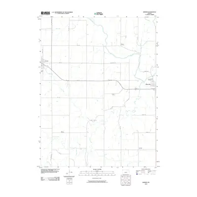
2009 Map of Barnes
USGS Topo · Published 2009About this map
The Little Blue River and its numerous tributaries, including Mercer Creek and Walnut Creek, define the rolling agricultural landscape of Marshall County. At the beginning of the twenty-first century, the grid-patterned towns of Barnes and Waterville serve as the primary hubs of activity, connected by the arcing route of Ksthy 9. The rural character of the region is punctuated by a high density of ancestral burial grounds, suggesting deep generational ties to the land. Genealogists will find the locations of Keefover Cemetery, Riverside Cemetery, Kenyon Cemetery, Mound Cemetery, and Harbaugh Cemetery invaluable for tracing local family histories. The intricate network of local roads like Tumbleweed Rd and Cross Creek Rd provides access to the smaller creeks, such as Coon Creek and Sulphur Creek, that drain this prairie terrain.
Find a feature on this map
38 named features on this map. Tap any name to fly to it.
Don’t see what you’re looking for? This feature index may not catch every label — zoom into the map to look around manually.
Map Details
Editions of this 2009 Barnes Map
This is the sole edition of this map. No revisions or reprints were ever made.
Other maps of this area

1889 · Marysville
USGS Topo · 1:125,000

1894 · Marysville
USGS Topo · 1:125,000

1955 · Manhattan
USGS Topo · 1:250,000

1956 · Manhattan
USGS Topo · 1:250,000

1957 · Manhattan
USGS Topo · 1:250,000

1966 · Marysville
USGS Topo · 1:24,000

1966 · Hanover SE
USGS Topo · 1:24,000

1966 · Hanover SW
USGS Topo · 1:24,000
1968 · Kimeo
USGS Topo · 1:24,000
1968 · Greenleaf
USGS Topo · 1:24,000