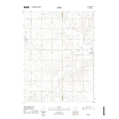
2018 Map of Barnes
USGS Topo · Published 2018About this map
The Little Blue River winds through the eastern portion of this landscape, anchoring the town of Waterville as it transitions from the river valley to the uplands of the Washington and Marshall County line. To the west, the town of Barnes sits near the headwaters of Camp Cr, illustrating a classic Kansas settlement pattern where community centers developed along established section-line roads like All American Rd and 10th Rd. Rural life in this area is marked by numerous family and community burial grounds, including Riverside Cem overlooking the river and the isolated Harbaugh Cem to the south. The drainage network is dense, with Coon Creek and Sulphur Cr cutting through the rolling terrain, showing how water sources dictated the early division of land and road placements in this part of Kansas.
Find a feature on this map
54 named features on this map. Tap any name to fly to it.
Don’t see what you’re looking for? This feature index may not catch every label — zoom into the map to look around manually.
Map Details
Editions of this 2018 Barnes Map
This is the sole edition of this map. No revisions or reprints were ever made.
Other maps of this area

1889 · Marysville
USGS Topo · 1:125,000

1894 · Marysville
USGS Topo · 1:125,000

1955 · Manhattan
USGS Topo · 1:250,000

1956 · Manhattan
USGS Topo · 1:250,000

1957 · Manhattan
USGS Topo · 1:250,000

1966 · Marysville
USGS Topo · 1:24,000

1966 · Hanover SE
USGS Topo · 1:24,000

1966 · Hanover SW
USGS Topo · 1:24,000
1968 · Kimeo
USGS Topo · 1:24,000
1968 · Greenleaf
USGS Topo · 1:24,000