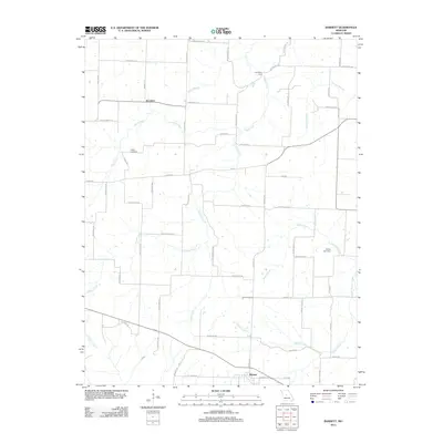
2011 Map of Barnett
USGS Topo · Published 2011About this map
Barnett and Excelsior anchor this central Missouri landscape, where the headwaters of the South Moreau Creek and its many tributaries carve a network of drainage across the terrain. The hydrology is the defining characteristic of the area, with Burris Fork, Gracey Creek, and Jones Creek weaving between a dense grid of rural roads such as Providence Rd and Highway C. A distinct historical crossing point is noted at Coal Bank Ford on the Burris Fork, suggesting an older pattern of travel before modern bridges were established. Local genealogy is supported by the presence of the Kelsay Cemetery and Phillips Cemetery, which serve as quiet landmarks for the families who settled this agricultural region. The map reveals a transition from the structured street plan of Barnett to the more dispersed rural homesteads connected by lanes like Buttercup Rd and Shadey Brook Dr.
Find a feature on this map
60 named features on this map. Tap any name to fly to it.
Don’t see what you’re looking for? This feature index may not catch every label — zoom into the map to look around manually.
Map Details
Editions of this 2011 Barnett Map
This is the sole edition of this map. No revisions or reprints were ever made.
Other maps of this area

1888 · Versailles
USGS Topo · 1:125,000

1888 · Boonville
USGS Topo · 1:125,000

1893 · Versailles
USGS Topo · 1:125,000

1904 · Eldon
USGS Topo · 1:62,500

1904 · Gravois Mills
USGS Topo · 1:62,500

1935 · Gravois Mills
USGS Topo · 1:24,000

1935 · Rocky Mount
USGS Topo · 1:24,000
1935 · Eldon
USGS Topo · 1:24,000

1947 · Jefferson City
USGS Topo · 1:250,000

1949 · Gravois Mills
USGS Topo · 1:62,500