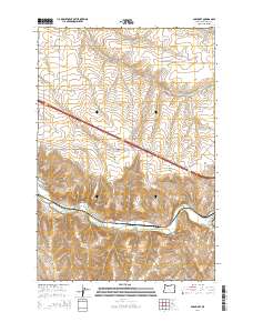
2014 Map of Barnhart
USGS Topo · Published 2014About this map
The Umatilla River carves a significant path through this part of Umatilla County, Oregon, defining the local geography as it flows past the small settlement of Rieth. This area is characterized by a high-desert plateau bisected by deep drainage systems such as Coombs Canyon and Stage Gulch. The transportation network is a mixture of modern thoroughfares and older rural routes, including the historic alignment of Stage Gulch Rd and Yoakum Rd. Just south of Rieth Ridge, the map shows the transition from these high plateaus down to the river valley, where the infrastructure of the settlement of Barnhart sits along the water. For genealogists and local historians, the proximity of Rieth Bridge and the confluence of Birch Cr with the river provide specific points of reference for tracing early land use and the development of this agricultural and transit corridor west of Pendleton.
Find a feature on this map
30 named features on this map. Tap any name to fly to it.
Don’t see what you’re looking for? This feature index may not catch every label — zoom into the map to look around manually.
Map Details
Editions of this 2014 Barnhart Map
This is the sole edition of this map. No revisions or reprints were ever made.
Other maps of this area

1908 · Umatilla
USGS Topo · 1:125,000

1935 · Pendleton
USGS Topo · 1:125,000

1953 · Pendleton
USGS Topo · 1:250,000

1956 · Pendleton
USGS Topo · 1:250,000

1962 · Stanfield SE
USGS Topo · 1:24,000

1966 · Mc Kay Reservoir
USGS Topo · 1:24,000

1966 · Holdman
USGS Topo · 1:24,000

1966 · Holdman SE
USGS Topo · 1:24,000

1966 · Pendleton
USGS Topo · 1:24,000
1966 · Barnhart
USGS Topo · 1:24,000