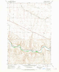
1966 Map of Barnhart
USGS Topo · Published 1967About this map
The Umatilla River valley dominates this mid-1960s survey, showing a landscape defined by industrial and transportation corridors in eastern Oregon. The Union Pacific railroad tracks hug the river's path, serving the settlements of Barnhart and Rieth. On the northern plateau, the land rises toward Rieth Ridge, where a radio facility and modern infrastructure like Storage Bins and a 3 lane roadway signify the region's mid-century development. The rugged southern terrain is carved by Coombs Canyon and several unnamed springs, while local industry is noted through a quarry and a gaging sta near the mouth of Birch Creek. This survey captures the transition from the river-bottom rail hubs to the sprawling high-desert plateaus and winding gulches like Stage Gulch that characterize Umatilla County.
Find a feature on this map
15 named features on this map. Tap any name to fly to it.
Don’t see what you’re looking for? This feature index may not catch every label — zoom into the map to look around manually.
Map Details
Editions of this 1966 Barnhart Map
2 editions found
Other maps of this area

1908 · Umatilla
USGS Topo · 1:125,000

1935 · Pendleton
USGS Topo · 1:125,000

1953 · Pendleton
USGS Topo · 1:250,000

1956 · Pendleton
USGS Topo · 1:250,000

1962 · Stanfield SE
USGS Topo · 1:24,000

1966 · Mc Kay Reservoir
USGS Topo · 1:24,000

1966 · Holdman
USGS Topo · 1:24,000

1966 · Holdman SE
USGS Topo · 1:24,000

1966 · Pendleton
USGS Topo · 1:24,000
1966 · Coombs Canyon
USGS Topo · 1:24,000