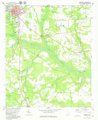
1979 Map of Barnwell
USGS Topo · Published 1980About this map
The Salkehatchie River and its expansive swampy bottomlands dominate this landscape, flanked by the railroad town of Barnwell and smaller rural nodes like Kline and Yenome. The mapping shows a transition from the structured street grid of the county seat — featuring the Guinyard-Butler Middle Sch and a State Fish Hatchery — to the dispersed agricultural and industrial sites of the surrounding Lowcountry. Traces of older river-based industry appear at Hagoods Mill on Toby Creek, while the presence of numerous small congregations, including Mt Lebanon Ch and Morris Chapel, suggests a landscape shaped by tight-knit rural communities. The rail network, featuring the Seaboard Coast Line and Southern tracks, remains the backbone of the region's 1970s economic geography, connecting local resources like the Claypit and Sand and Gravel Pit to wider markets.
Find a feature on this map
49 named features on this map. Tap any name to fly to it.
Don’t see what you’re looking for? This feature index may not catch every label — zoom into the map to look around manually.
Map Details
Editions of this 1979 Barnwell Map
2 editions found
Other maps of this area

1919 · Olar
USGS Topo · 1:62,500

1919 · Bamberg
USGS Topo · 1:48,000

1919 · Allendale
USGS Topo · 1:62,500

1920 · Bamberg
USGS Topo · 1:62,500

1923 · Williston
USGS Topo · 1:48,000

1927 · Williston
USGS Topo · 1:62,500

1943 · Olar
USGS Topo · 1:62,500

1943 · Allendale
USGS Topo · 1:62,500

1943 · Bamberg
USGS Topo · 1:62,500

1943 · Williston
USGS Topo · 1:62,500