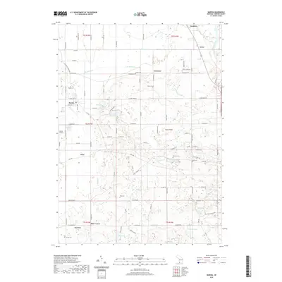
2019 Map of Baroda
USGS Topo · Published 2019About this map
Baroda serves as the central hub of this agricultural landscape in Berrien County, where a network of rural roads such as Cleveland Ave and Linco Rd connect small settlements and family farmsteads. The terrain is defined by a dense system of drains and creeks, including Hickory Cr and Lemon Cr, which feed into the Saint Joseph River at the eastern edge. This hydrography suggests a long history of land management for farming, evidenced by the numerous named drains like Big Meadow Drain and Shuler Drain. Genealogists will find a high density of rural burial grounds, such as Hinman Cem, Ruggles Cem, and Feather Cem, marking the early centers of community life in hamlets like Snow, Arden, and Glendora. The presence of the Baroda Airport and the transition from traditional farming to more diverse land use is visible in the parcel patterns surrounding Hess Lake and Singer Lake.
Find a feature on this map
100 named features on this map. Tap any name to fly to it.
Don’t see what you’re looking for? This feature index may not catch every label — zoom into the map to look around manually.
Map Details
Editions of this 2019 Baroda Map
This is the sole edition of this map. No revisions or reprints were ever made.
Other maps of this area

1927 · Niles
USGS Topo · 1:62,500

1927 · Benton Harbor
USGS Topo · 1:62,500

1930 · Three Oaks
USGS Topo · 1:62,500

1930 · Benton Harbor
USGS Topo · 1:62,500

1930 · Niles
USGS Topo · 1:62,500

1943 · Niles
USGS Topo · 1:62,500

1944 · Three Oaks
USGS Topo · 1:62,500

1953 · Chicago
USGS Topo · 1:250,000

1957 · Chicago
USGS Topo · 1:250,000

1958 · Racine
USGS Topo · 1:250,000