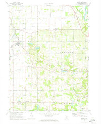
1970 Map of Baroda
USGS Topo · Published 1973About this map
The village of Baroda serves as a central hub in this agricultural landscape of Berrien County, where the C & O RR tracks run parallel to Hickory Creek. The terrain is defined by a series of small, glacial kettle lakes and drains, including Singer Lake, Hess Lake, and Madron Lake, interspersed with active industrial sites like the Sandpit and various Gravel Pits. Local infrastructure from the early 1970s is well-documented, showing the Hickox Landing Strip and a Water Tank in the heart of town.
Find a feature on this map
55 named features on this map. Tap any name to fly to it.
Don’t see what you’re looking for? This feature index may not catch every label — zoom into the map to look around manually.
Map Details
Editions of this 1970 Baroda Map
This is the sole edition of this map. No revisions or reprints were ever made.
Other maps of this area

1927 · Niles
USGS Topo · 1:62,500

1927 · Benton Harbor
USGS Topo · 1:62,500

1930 · Three Oaks
USGS Topo · 1:62,500

1930 · Benton Harbor
USGS Topo · 1:62,500

1930 · Niles
USGS Topo · 1:62,500

1943 · Niles
USGS Topo · 1:62,500

1944 · Three Oaks
USGS Topo · 1:62,500

1953 · Chicago
USGS Topo · 1:250,000

1957 · Chicago
USGS Topo · 1:250,000

1958 · Racine
USGS Topo · 1:250,000