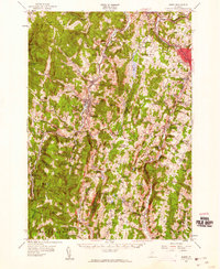
1957 Map of Barre
USGS Topo · Published 1960About this map
The central Vermont highlands are documented here during the late 1950s, a period when the mountainous landscape of Washington and Orange counties maintained a balance between its industrial valleys and rural hills. Norwich University sits at the heart of Northfield, while the Central Vermont railroad follows the course of the Dog River through the narrow valley. The map reveals the intricate network of the area's secondary education and recreation, from one-room schoolhouses like No 12 Sch and the Baptist Street Sch to the established Teela-Wooket Camp.
Find a feature on this map
117 named features on this map. Tap any name to fly to it.
Don’t see what you’re looking for? This feature index may not catch every label — zoom into the map to look around manually.
Map Details
Editions of this 1957 Barre Map
3 editions found
Other maps of this area

1896 · Strafford
USGS Topo · 1:62,500

1915 · Rochester
USGS Topo · 1:62,500

1917 · Rochester
USGS Topo · 1:62,500

1919 · Royalton
USGS Topo · 1:62,500

1919 · Lincoln Mountain
USGS Topo · 1:62,500

1919 · Montpelier
USGS Topo · 1:62,500

1920 · Lincoln Mountain
USGS Topo · 1:48,000

1921 · Richmond
USGS Topo · 1:48,000

1921 · Lincoln Mountain
USGS Topo · 1:62,500

1921 · Montpelier
USGS Topo · 1:62,500