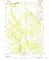
1966 Map of Barrel Springs
USGS Topo · Published 1973About this map
Oregon Nevada and California Nevada state lines converge in this 1960s survey of a high-desert landscape. The isolated settlement of Susila sits at a junction of valley routes, surrounded by a complex network of seasonal water sources including Barrel Springs and Horse Creek. These water points were critical for livestock and travel through the arid high country of Washoe County. The terrain is marked by numerous unnamed Springs and the drainage of Twelvemile Creek, reflecting a region where geography is defined by access to water. Human impact on the land is represented by a solitary Gravel Pit and a web of Jeep Trails that traverse the ridges and basins, indicating the continued use of this remote borderland for ranching or exploration.
Find a feature on this map
12 named features on this map. Tap any name to fly to it.
Don’t see what you’re looking for? This feature index may not catch every label — zoom into the map to look around manually.
Map Details
Editions of this 1966 Barrel Springs Map
2 editions found
Other maps of this area

1886 · Alturas
USGS Topo · 1:250,000

1889 · Long Valley
USGS Topo · 1:250,000

1892 · Alturas
USGS Topo · 1:250,000

1954 · Vya
USGS Topo · 1:250,000

1954 · Alturas
USGS Topo · 1:250,000

1955 · Klamath Falls
USGS Topo · 1:250,000

1955 · Adel
USGS Topo · 1:250,000

1957 · Adel
USGS Topo · 1:250,000

1958 · Alturas
USGS Topo · 1:250,000

1958 · Klamath Falls
USGS Topo · 1:250,000