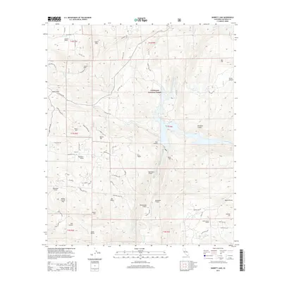
2015 Map of Barrett Lake
USGS Topo · Published 2015About this map
Cleveland National Forest dominates the high-elevation landscape of San Diego County in this detailed 2015 study, centered around the vital waters of Barrett Lake. The terrain is defined by a series of prominent summits including Mother Grundy Peak, Lawson Peak, and Gaskill Peak, which oversee a network of distinct valleys such as Lawson Valley, Lyons Valley, and Deerhorn Valley. The intricate water systems are clearly marked, featuring Cottonwood Cr and the engineered San Diego City Conduit flowing through deep canyons like Boneyard Canyon and Rattlesnake Canyon. This survey captures the complex intersection of public forest land and small rural developments, noted by a web of local roads like Honey Springs Rd and Deerhorn Valley Rd. Small-scale aviation history is represented by the Reider Ranch Airport near Round Potrero, illustrating the area's ongoing blend of wilderness and private homesteads.
Find a feature on this map
69 named features on this map. Tap any name to fly to it.
Don’t see what you’re looking for? This feature index may not catch every label — zoom into the map to look around manually.
Map Details
Editions of this 2015 Barrett Lake Map
This is the sole edition of this map. No revisions or reprints were ever made.
Other maps of this area

1893 · El Cajon
USGS Topo · 1:62,500

1901 · Elcajon
USGS Topo · 1:62,500

1903 · Cuyamaca
USGS Topo · 1:125,000

1903 · Elcajon
USGS Topo · 1:62,500

1904 · Southern California Sheet No. 2
USGS Topo · 1:250,000

1939 · El Cajon
USGS Topo · 1:62,500

1942 · Potrero
USGS Topo · 1:48,000

1942 · El Cajon
USGS Topo · 1:62,500

1942 · Cuyamaca Peak
USGS Topo · 1:62,500

1943 · Jamul
USGS Topo · 1:62,500