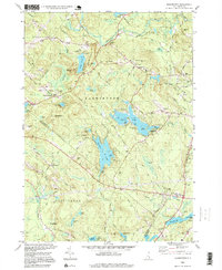
1995 Map of Barrington
USGS Topo · Published 1999About this map
Swains Lake and the complex waterways of the Isinglass River drainage define this section of the New Hampshire interior during the late twentieth century. The map reveals a landscape heavily influenced by the University of New Hampshire, noting the UNH Recreation Area at Mendums Pond and the UNH Sch of Continuing Studies further south. Settlement is concentrated around the historic hubs of Barrington and East Barrington, while the surrounding terrain is marked by family-named landmarks like Berrys Hill and Nippo Hill. The presence of multiple cemeteries, including Pine Grove Cem, and public lands such as the Nottingham State Forest suggest a community balancing conservation with its colonial-era roots. Numerous trailer parks and campgrounds near water bodies like Ayers Pond reflect the region's enduring role as a destination for outdoor recreation and seasonal residency.
Find a feature on this map
68 named features on this map. Tap any name to fly to it.
Don’t see what you’re looking for? This feature index may not catch every label — zoom into the map to look around manually.
Map Details
Editions of this 1995 Barrington Map
This is the sole edition of this map. No revisions or reprints were ever made.
Other maps of this area

1891 · Berwick
USGS Topo · 1:62,500

1893 · Dover
USGS Topo · 1:62,500

1893 · Berwick
USGS Topo · 1:62,500

1916 · Dover
USGS Topo · 1:62,500

1917 · Mt. Pawtuckaway
USGS Topo · 1:62,500

1918 · Dover
USGS Topo · 1:62,500

1919 · Mt. Pawtuckaway
USGS Topo · 1:62,500

1919 · Alton
USGS Topo · 1:62,500

1933 · Berwick
USGS Topo · 1:48,000

1937 · Berwick
USGS Topo · 1:62,500