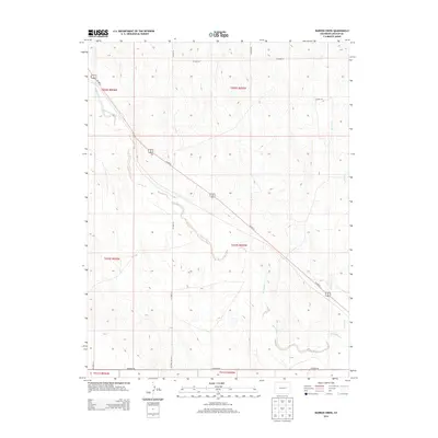
2013 Map of Barron Creek
USGS Topo · Published 2013About this map
Big Sandy Creek meanders through this high plains landscape of Lincoln County, defining the drainage patterns of a region deeply marked by the Public Land Survey System. The map reveals the rigid grid of the township and range lines, such as t010s r055w, which dictate the placement of local thoroughfares like CO Road 26 and CO Road 2W. These section-line roads carve the open terrain into precise rectangular blocks, a hallmark of Western settlement and land management. Along the eastern edge, Barron Cr provides a secondary focal point for the local topography. This document serves as a detailed record of the rural infrastructure in the early 21st century, showing the intersection of major transit routes like Us-287 N with the local county road network that supports the area's agricultural life.
Find a feature on this map
16 named features on this map. Tap any name to fly to it.
Don’t see what you’re looking for? This feature index may not catch every label — zoom into the map to look around manually.
Map Details
Editions of this 2013 Barron Creek Map
This is the sole edition of this map. No revisions or reprints were ever made.
Other maps of this area

1891 · Limon
USGS Topo · 1:125,000

1892 · Limon
USGS Topo · 1:125,000

1954 · Limon
USGS Topo · 1:250,000

1957 · Limon
USGS Topo · 1:250,000

1958 · Limon
USGS Topo · 1:250,000

1970 · Limon
USGS Topo · 1:24,000

1970 · Four Corners
USGS Topo · 1:24,000
1970 · Long Creek
USGS Topo · 1:24,000
1979 · Barron Creek
USGS Topo · 1:24,000

1979 · Genoa East
USGS Topo · 1:24,000