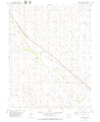
1979 Map of Barron Creek
USGS Topo · Published 1979About this map
Union Pacific tracks cut a distinct diagonal path across this high plains landscape, following the general course of the broad Big Sandy Creek valley in Lincoln County. The mapping reveals a sparse, water-dependent infrastructure defined by numerous wells and cattle tanks scattered across the terrain, reflecting the region's ranching character. Near the railroad siding at Sandy, the topography shows industrial activity with multiple Gravel Pits, likely utilized for rail ballast or local road building. The drainage network is clearly defined by the branching paths of Sandy Creek and Barron Creek, which carve subtle relief into the surrounding prairie. This 1970s survey captures a moment when the rural landscape remained largely open, punctuated only by a major Pipeline and the essential rail corridor that connects these remote plains to larger transport networks.
Find a feature on this map
9 named features on this map. Tap any name to fly to it.
Don’t see what you’re looking for? This feature index may not catch every label — zoom into the map to look around manually.
Map Details
Editions of this 1979 Barron Creek Map
This is the sole edition of this map. No revisions or reprints were ever made.
Other maps of this area

1891 · Limon
USGS Topo · 1:125,000

1892 · Limon
USGS Topo · 1:125,000

1954 · Limon
USGS Topo · 1:250,000

1957 · Limon
USGS Topo · 1:250,000

1958 · Limon
USGS Topo · 1:250,000

1970 · Limon
USGS Topo · 1:24,000

1970 · Four Corners
USGS Topo · 1:24,000
1970 · Long Creek
USGS Topo · 1:24,000

1979 · Genoa East
USGS Topo · 1:24,000
1979 · Lake SE
USGS Topo · 1:24,000