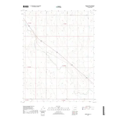
2019 Map of Barron Creek
USGS Topo · Published 2019About this map
Big Sandy Creek flows southeast across this stretch of the Colorado plains in Lincoln County, carving a wide, shallow valley through the arid landscape. The area is defined by its rural section-line road network and the diagonal path of US Highway 40/287, which connects the region's scattered agricultural tracts. The map illustrates a high-plains environment where water is the primary architect of the terrain, as seen in the drainage of Barron Cr and the numerous unnamed draws that feed into the main Big Sandy Creek basin. County infrastructure, including Co RD 26 and Co RD 3e, provides the primary access to the large ranching and farming divisions within Townships 9, 10, and 11 South. This survey is an essential document for understanding the modern rural layout and land use of the eastern Colorado plains.
Find a feature on this map
15 named features on this map. Tap any name to fly to it.
Don’t see what you’re looking for? This feature index may not catch every label — zoom into the map to look around manually.
Map Details
Editions of this 2019 Barron Creek Map
This is the sole edition of this map. No revisions or reprints were ever made.
Other maps of this area

1891 · Limon
USGS Topo · 1:125,000

1892 · Limon
USGS Topo · 1:125,000

1954 · Limon
USGS Topo · 1:250,000

1957 · Limon
USGS Topo · 1:250,000

1958 · Limon
USGS Topo · 1:250,000

1970 · Limon
USGS Topo · 1:24,000

1970 · Four Corners
USGS Topo · 1:24,000
1970 · Long Creek
USGS Topo · 1:24,000
1979 · Barron Creek
USGS Topo · 1:24,000

1979 · Genoa East
USGS Topo · 1:24,000