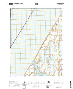
2020 Map of Barrow A-5 NE
USGS Topo · Published 2020About this map
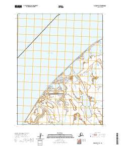
Utqiaġvik marks the northern extent of this coastline along the Chukchi Sea, where the Arctic landscape transitions from open water to a dense network of wetlands and thaw lakes. The shoreline is punctuated by prominent coastal features like Point Shadden, which guards the entrance to the recessed waters of Walakpa Bay. This 2020 survey illustrates the modern topography of the North Slope, defined by the intricate hydrology of the tundra and the maritime influence of the high Arctic. The map highlights the vast stretches of unnamed water bodies and saturated ground that characterize the region, showing how the land meets the sea at one of the northernmost points of the United States.
Find a feature on this map
7 named features on this map. Tap any name to fly to it.
Don’t see what you’re looking for? This feature index may not catch every label — zoom into the map to look around manually.
Map Details
Editions of this 2020 Barrow A-5 NE Map
This is the sole edition of this map. No revisions or reprints were ever made.
Other maps of this area

1945 · Barrow
USGS Topo · 1:250,000

1949 · Barrow
USGS Topo · 1:250,000

1955 · Barrow
USGS Topo · 1:250,000

1955 · Barrow B-4
USGS Topo · 1:63,360

1955 · Barrow A-4
USGS Topo · 1:63,360

1955 · Barrow A-5
USGS Topo · 1:63,360
1962 · Barrow B-4
USGS Topo · 1:50,000
1962 · Barrow A-4
USGS Topo · 1:50,000
1973 · Barrow B-4
USGS Topo · 1:63,360
2020 · Barrow B-4 SW
USGS Topo · 1:25,000