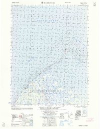
1962 Map of Barrow B-4
USGS Topo · Published 1962About this map
Point Barrow marks the northernmost extremity of this coastal survey, where the Arctic Ocean, Beaufort Sea, and Chukchi Sea converge. The settlement of Barrow is the primary hub, featuring a Church, Hospital, and Barrow Airfield. This Cold War-era mapping effort highlights the strategic importance of the Naval Petroleum Reserve No 4, reflecting mid-century energy exploration with features like Gas Well No 4 and an Avak Test Hole.
Find a feature on this map
23 named features on this map. Tap any name to fly to it.
Don’t see what you’re looking for? This feature index may not catch every label — zoom into the map to look around manually.
Map Details
Editions of this 1962 Barrow B-4 Map
This is the sole edition of this map. No revisions or reprints were ever made.
Other maps of this area

1945 · Barrow
USGS Topo · 1:250,000

1949 · Barrow
USGS Topo · 1:250,000

1955 · Barrow
USGS Topo · 1:250,000

1955 · Barrow B-4
USGS Topo · 1:63,360

1955 · Barrow A-4
USGS Topo · 1:63,360

1955 · Barrow A-5
USGS Topo · 1:63,360

1955 · Barrow A-3
USGS Topo · 1:63,360
1955 · Barrow B-3
USGS Topo · 1:63,360
1962 · Barrow A-4
USGS Topo · 1:50,000
1973 · Barrow B-4
USGS Topo · 1:63,360