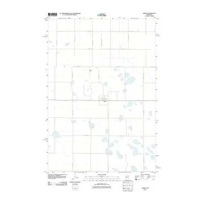
2010 Map of Barry
USGS Topo · Published 2010About this map
Barry serves as the central hub of this agricultural landscape in Big Stone County, defined by a rigid grid of county roads and drainage works characteristic of the Minnesota prairie. The small settlement is surrounded by water-filled depressions and engineered watercourses like Judicial Ditch Number Four, which facilitate the region's intensive farming. Notable natural features include Fogarty Lake and Clear Lake, while Stanley Field provides a localized landmark north of the town center. The network of routes, including County Hwy-54 and County Hwy-7, illustrates the connectivity between rural homesteads and the grain-handling infrastructure that supports the local economy. This survey documents the intersection of natural glacial hydrology and purposeful human modification in the early 21st century.
Find a feature on this map
14 named features on this map. Tap any name to fly to it.
Don’t see what you’re looking for? This feature index may not catch every label — zoom into the map to look around manually.
Map Details
Editions of this 2010 Barry Map
This is the sole edition of this map. No revisions or reprints were ever made.
Other maps of this area

1916 · Beardsley
USGS Topo · 1:62,500

1918 · Beardsley
USGS Topo · 1:62,500

1950 · Graceville
USGS Topo · 1:62,500

1953 · Ortonville
USGS Topo · 1:62,500

1953 · Milbank
USGS Topo · 1:250,000

1954 · Big Stone Lake
USGS Topo · 1:62,500

1958 · Milbank
USGS Topo · 1:250,000

1971 · Big Stone Lake East
USGS Topo · 1:24,000

1971 · Big Stone Lake West
USGS Topo · 1:24,000
1971 · Clinton
USGS Topo · 1:24,000