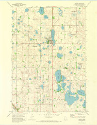
1971 Map of Clinton
USGS Topo · Published 1974About this map
The town of Clinton sits at the heart of this Big Stone County landscape, defined by a dense network of glacial lakes and prairie wetlands. The Chicago Milwaukee St Paul and Pacific railroad tracks bisect the region, anchoring the local economy and the settlement pattern of the early 1970s. This survey, based on aerial photography from the era, highlights the conservation footprint of the National Waterfowl Production Area and the Finberg State Wildlife Management Area, which preserve the original prairie pothole character of the terrain.
Find a feature on this map
31 named features on this map. Tap any name to fly to it.
Don’t see what you’re looking for? This feature index may not catch every label — zoom into the map to look around manually.
Map Details
Editions of this 1971 Clinton Map
This is the sole edition of this map. No revisions or reprints were ever made.
Other maps of this area

1916 · Beardsley
USGS Topo · 1:62,500

1918 · Beardsley
USGS Topo · 1:62,500

1950 · Graceville
USGS Topo · 1:62,500

1953 · Ortonville
USGS Topo · 1:62,500

1953 · Milbank
USGS Topo · 1:250,000

1954 · Big Stone Lake
USGS Topo · 1:62,500

1958 · Milbank
USGS Topo · 1:250,000

1971 · Big Stone Lake East
USGS Topo · 1:24,000

1971 · Dismal Swamp
USGS Topo · 1:24,000

1971 · Odessa
USGS Topo · 1:24,000