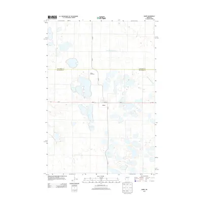
2013 Map of Barry
USGS Topo · Published 2013About this map
Barry serves as the central settlement point in this western Minnesota landscape, situated at the intersection of Mn-28 and Co Hwy-7. The geography is defined by a high concentration of small lakes and wetlands, most notably Fogarty Lake and Clear Lake, which are characteristic of the prairie pothole region. This map illustrates the intersection of agricultural land management and natural drainage, as seen in the engineered watercourses like Judicial Ditch Number Four that navigate the terrain. The presence of Stanley Field Airport north of the town center indicates the area's continued utility as a local aviation and transportation node. The boundary between Traverse Co and Big Stone Co bisects the northern section of the map, marking a primary administrative divide through the open countryside and past local routes like Larkin Ave.
Find a feature on this map
10 named features on this map. Tap any name to fly to it.
Don’t see what you’re looking for? This feature index may not catch every label — zoom into the map to look around manually.
Map Details
Editions of this 2013 Barry Map
This is the sole edition of this map. No revisions or reprints were ever made.
Other maps of this area

1916 · Beardsley
USGS Topo · 1:62,500

1918 · Beardsley
USGS Topo · 1:62,500

1950 · Graceville
USGS Topo · 1:62,500

1953 · Ortonville
USGS Topo · 1:62,500

1953 · Milbank
USGS Topo · 1:250,000

1954 · Big Stone Lake
USGS Topo · 1:62,500

1958 · Milbank
USGS Topo · 1:250,000

1971 · Big Stone Lake East
USGS Topo · 1:24,000

1971 · Big Stone Lake West
USGS Topo · 1:24,000
1971 · Clinton
USGS Topo · 1:24,000