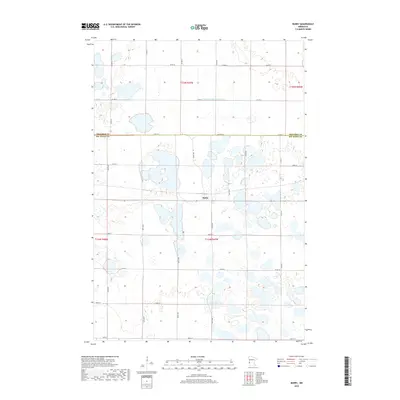
2019 Map of Barry
USGS Topo · Published 2019About this map
Barry serves as the central hub of this prairie landscape, situated near the shared boundary of Traverse Co Big Stone Co. The surrounding terrain is defined by a dense network of seasonal wetlands and distinctive water bodies, including the centrally located Fogarty Lake and the larger Clear Lake to the south. Human modification of the natural hydrology is evident in the straight course of Judicial Ditch Number Four, which cuts across the northern townships to manage the region's complex drainage. The map reveals a highly structured grid of section lines and rural roads such as Co Hwy 13 and 800th Ave, reflecting the enduring agricultural organization of this Minnesota borderland. This 2019 survey provides a precise account of the modern rural infrastructure and water features that continue to shape the character of both Big Stone and Traverse counties.
Find a feature on this map
30 named features on this map. Tap any name to fly to it.
Don’t see what you’re looking for? This feature index may not catch every label — zoom into the map to look around manually.
Map Details
Editions of this 2019 Barry Map
This is the sole edition of this map. No revisions or reprints were ever made.
Other maps of this area

1916 · Beardsley
USGS Topo · 1:62,500

1918 · Beardsley
USGS Topo · 1:62,500

1950 · Graceville
USGS Topo · 1:62,500

1953 · Ortonville
USGS Topo · 1:62,500

1953 · Milbank
USGS Topo · 1:250,000

1954 · Big Stone Lake
USGS Topo · 1:62,500

1958 · Milbank
USGS Topo · 1:250,000

1971 · Big Stone Lake East
USGS Topo · 1:24,000

1971 · Big Stone Lake West
USGS Topo · 1:24,000
1971 · Clinton
USGS Topo · 1:24,000