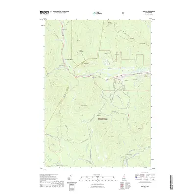
2021 Map of Bartlett
USGS Topo · Published 2021About this map
Bartlett sits at the heart of this White Mountains landscape, where the Saco River and Crawford Notch RD serve as the primary corridors for travel and settlement. The terrain is defined by significant elevations like Mt Parker and Bear Mtn, while the White Mountain National Forest encompasses the majority of the region's southern and central reaches. Local history is evidenced by family names on rural routes such as Stanton Farm Rd, Cobb Farm Rd, and Yates Farm Rd, suggesting the area's agricultural past alongside its modern identity as a recreation hub. The map traces an extensive network of trails, including the Nancy Pond Trl and various snowmobile routes like the Bear Notch Rd Snomo Trl, which connect the small settlements of Notchland and Sawyers River to the high ridges of Montalban Ridge and Bemis Ridge.
Find a feature on this map
77 named features on this map. Tap any name to fly to it.
Don’t see what you’re looking for? This feature index may not catch every label — zoom into the map to look around manually.
Map Details
Editions of this 2021 Bartlett Map
This is the sole edition of this map. No revisions or reprints were ever made.
Other maps of this area

1894 · North Conway
USGS Topo · 1:62,500

1895 · Crawford Notch
USGS Topo · 1:62,500

1896 · Crawford Notch
USGS Topo · 1:62,500

1896 · North Conway
USGS Topo · 1:62,500

1930 · Ossipee Lake
USGS Topo · 1:62,500

1931 · Mt. Chocorua
USGS Topo · 1:62,500

1942 · North Conway
USGS Topo · 1:62,500

1945 · North Conway
USGS Topo · 1:62,500

1946 · Crawford Notch
USGS Topo · 1:62,500

1949 · Portland
USGS Topo · 1:250,000