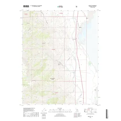
2018 Map of Bartlett
USGS Topo · Published 2018About this map
Sierra Nevada peaks tower over the western edge of the high desert in this 2018 survey of the Owens Valley. The settlement of Bartlett sits along the western shoreline of Owens Lake, positioned where the valley floor meets the steep ascent into the Inyo National Forest. This landscape is defined by the critical infrastructure of the Los Angeles Aqueduct, which runs parallel to the highway, tracing the base of the mountains to capture runoff. The map documents an area of extreme elevation change, from the dry lake bed up to summits like Wonoga Peak and Muah Mtn. Deep canyons such as Slide Canyon and Wormhole Canyon carve through the eastern slopes, while routes like Horseshoe Meadows Rd provide access to the high backcountry. This edition captures the contemporary water management systems and wilderness boundaries that shape the modern Eastern Sierra.
Find a feature on this map
27 named features on this map. Tap any name to fly to it.
Don’t see what you’re looking for? This feature index may not catch every label — zoom into the map to look around manually.
Map Details
Editions of this 2018 Bartlett Map
This is the sole edition of this map. No revisions or reprints were ever made.
Other maps of this area

1905 · Olancha
USGS Topo · 1:125,000

1907 · Olancha
USGS Topo · 1:125,000

1907 · Mt. Whitney
USGS Topo · 1:125,000

1908 · Ballarat
USGS Topo · 1:250,000

1913 · Ballarat
USGS Topo · 1:250,000

1919 · Mt. Whitney
USGS Topo · 1:125,000

1937 · Mt. Whitney
USGS Topo · 1:125,000

1948 · Death Valley
USGS Topo · 1:250,000

1948 · Fresno
USGS Topo · 1:250,000

1950 · New York Butte
USGS Topo · 1:62,500