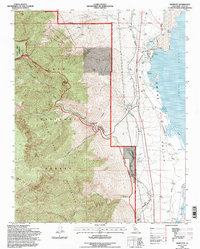
1994 Map of Bartlett
USGS Topo · Published 1997About this map
Owens Valley landscape in the mid-1990s is defined by the stark transition from the high peaks of the Golden Trout Wilderness down to the eastern shores of Owens Lake. This survey illustrates the complex water and industrial infrastructure of the region, anchored by the Los Angeles Aqueduct as it skirts the base of the mountains. At the settlement of Bartlett, the map details a landscape of specialized industry, including Soda Evaporators and an Old Railroad Grade that speaks to the area's history of mineral extraction. Higher elevations within the Inyo National Forest are dominated by prominent summits such as Wonoga Peak and Muah Mountain, with drainage systems like Cottonwood Creek feeding into the valley. The presence of the Cottonwood Power Plant and various Borrow Pits further emphasizes the managed nature of this environment at the turn of the 21st century.
Find a feature on this map
30 named features on this map. Tap any name to fly to it.
Don’t see what you’re looking for? This feature index may not catch every label — zoom into the map to look around manually.
Map Details
Editions of this 1994 Bartlett Map
This is the sole edition of this map. No revisions or reprints were ever made.
Other maps of this area

1905 · Olancha
USGS Topo · 1:125,000

1907 · Olancha
USGS Topo · 1:125,000

1907 · Mt. Whitney
USGS Topo · 1:125,000

1908 · Ballarat
USGS Topo · 1:250,000

1913 · Ballarat
USGS Topo · 1:250,000

1919 · Mt. Whitney
USGS Topo · 1:125,000

1937 · Mt. Whitney
USGS Topo · 1:125,000

1948 · Death Valley
USGS Topo · 1:250,000

1948 · Fresno
USGS Topo · 1:250,000

1950 · New York Butte
USGS Topo · 1:62,500