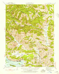
1942 Map of Bartlett Springs
USGS Topo · Published 1942About this map
Bartlett Springs and the surrounding high-country watersheds define this 1942 survey of the North Coast Ranges. The map illustrates a landscape shaped by geothermal activity and early 20th-century ranching, with numerous mineral springs and camps like Green Flat Camp and CCC Camp scattered among the ridges. At the southern edge, the shoreline of Clear Lake reveals established lakeside communities at Clearlake Oaks and Glenhaven, alongside the industrial footprint of the Sulphur Bank Mine.
Find a feature on this map
109 named features on this map. Tap any name to fly to it.
Don’t see what you’re looking for? This feature index may not catch every label — zoom into the map to look around manually.
Map Details
Editions of this 1942 Bartlett Springs Map
This is the sole edition of this map. No revisions or reprints were ever made.
Other maps of this area
1920 · Venado
USGS Topo · 1:62,500
1921 · Kelseyville
USGS Topo · 1:62,500
1922 · Hullville
USGS Topo · 1:62,500
1924 · Bartlett Springs
USGS Topo · 1:62,500
1938 · Lakeport
USGS Topo · 1:62,500
1943 · Morgan Valley
USGS Topo · 1:62,500
1943 · Lodoga
USGS Topo · 1:62,500
1943 · Kelseyville
USGS Topo · 1:62,500
1944 · Bartlett Springs
USGS Topo · 1:62,500
1944 · Wilbur Springs
USGS Topo · 1:62,500