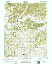
1978 Map of Bartlettsville
USGS Topo · Published 1988About this map
The northern reaches of Hoosier National Forest define this landscape along the Monroe Co Lawrence Co border, where the rugged southern Indiana topography meets the upper fingers of Monroe Lake. The map details a transition from the wooded ridges of Ramsey Ridge and Dutch Ridge to the agricultural bottoms and growing outskirts of Bedford. A distinct pattern of rural settlement is evident in small communities like Bartlettsville and Heltonville, supported by a network of country churches and family burial grounds including Covey Cem and Hawkins Cem. In the southern half, the Chicago Milwaukee St Paul and Pacific railroad tracks cut across the terrain near Shawswick, illustrating the region's transport links. Industrial presence is noted by a Quarry and scattered Oil Wells, while the presence of the Bedford-North Lawrence High Sch marks the encroaching suburbanization of the late 1970s.
Find a feature on this map
45 named features on this map. Tap any name to fly to it.
Don’t see what you’re looking for? This feature index may not catch every label — zoom into the map to look around manually.
Map Details
Editions of this 1978 Bartlettsville Map
3 editions found
Other maps of this area

1908 · Bloomington
USGS Topo · 1:48,000

1910 · Bloomington
USGS Topo · 1:62,500

1934 · Bedford
USGS Topo · 1:48,000

1935 · Oolitic
USGS Topo · 1:48,000

1937 · Bedford
USGS Topo · 1:62,500

1942 · Franklin
USGS Topo · 1:125,000

1942 · Oolitic
USGS Topo · 1:62,500

1947 · Allens Creek
USGS Topo · 1:24,000

1947 · Elkinsville
USGS Topo · 1:24,000
1950 · Elkinsville
USGS Topo · 1:24,000