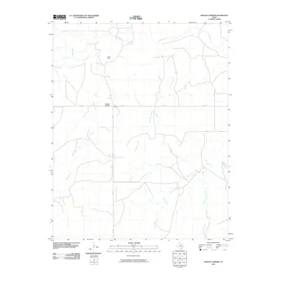
2010 Map of Barton Corners
USGS Topo · Published 2010About this map
Barton Corners serves as the central point of this high-plains landscape, where the intersection of FM 3260 and Co RD 6 anchors a network of rural roads. The geography is defined by a dendritic drainage system feeding into Wolf Creek, which meanders across the northern reaches of the quadrangle. Significant watercourses such as Buffalo Creek and East Buffalo Creek carve distinct paths through the terrain, illustrating the natural irrigation patterns of the Texas Panhandle. To the south, the landscape is shaped by the headwaters of Sand Creek and the South Prong Sand Creek. This 2010 survey reflects the enduring cattle-country character of Lipscomb County, showing the spatial relationship between isolated settlements and the vast drainages like Paine Draw and Gilhula Creek that define the open ranch land.
Find a feature on this map
12 named features on this map. Tap any name to fly to it.
Don’t see what you’re looking for? This feature index may not catch every label — zoom into the map to look around manually.
Map Details
Editions of this 2010 Barton Corners Map
This is the sole edition of this map. No revisions or reprints were ever made.
Other maps of this area

1954 · Perryton
USGS Topo · 1:250,000

1958 · Perryton
USGS Topo · 1:250,000

1972 · Barton Corners
USGS Topo · 1:24,000

1972 · Dugout Creek
USGS Topo · 1:24,000

1972 · Glazier
USGS Topo · 1:24,000

1972 · Lipscomb
USGS Topo · 1:24,000
1972 · Lipscomb SW
USGS Topo · 1:24,000

1972 · Twin Grove
USGS Topo · 1:24,000

1972 · Booker SE
USGS Topo · 1:24,000
1973 · Barton Creek
USGS Topo · 1:24,000