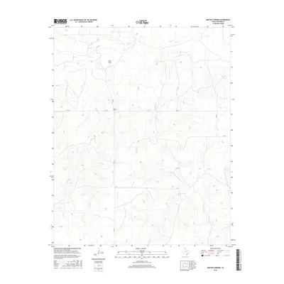
2016 Map of Barton Corners
USGS Topo · Published 2016About this map
Barton Corners marks a focal point of intersection in the north Texas Panhandle, situated where farm-to-market and county roads cross the rolling drainage basins of Lipscomb County. The landscape is defined by a dense network of intermittent waterways and seasonal draws, including Wolf Cr and the deeply incised Paine Draw. This 2016 survey illustrates the modern ranching and agricultural grid, where long-established routes like FM 3260 and Co RD 6 navigate around the meandering courses of Buffalo Cr and Sand Cr. The presence of these specific named tributaries, such as Gilhula Cr and E Buffalo Cr, highlights the critical importance of water management and topography in this corner of the High Plains.
Find a feature on this map
12 named features on this map. Tap any name to fly to it.
Don’t see what you’re looking for? This feature index may not catch every label — zoom into the map to look around manually.
Map Details
Editions of this 2016 Barton Corners Map
This is the sole edition of this map. No revisions or reprints were ever made.
Other maps of this area

1954 · Perryton
USGS Topo · 1:250,000

1958 · Perryton
USGS Topo · 1:250,000

1972 · Barton Corners
USGS Topo · 1:24,000

1972 · Dugout Creek
USGS Topo · 1:24,000

1972 · Glazier
USGS Topo · 1:24,000

1972 · Lipscomb
USGS Topo · 1:24,000
1972 · Lipscomb SW
USGS Topo · 1:24,000

1972 · Twin Grove
USGS Topo · 1:24,000

1972 · Booker SE
USGS Topo · 1:24,000
1973 · Barton Creek
USGS Topo · 1:24,000