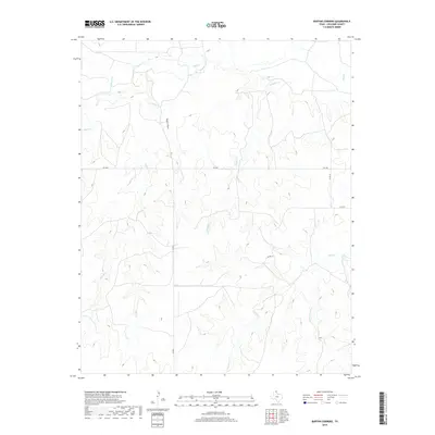
2019 Map of Barton Corners
USGS Topo · Published 2019About this map
Wolf Cr and its various tributaries define the drainage patterns of this rural Lipscomb County landscape in the Texas Panhandle. The terrain is marked by a network of seasonal watercourses and draws, including Paine Draw and Gilhula Cr, which feed into the larger creek systems. The map illustrates a largely undeveloped region where the primary infrastructure consists of a rectilinear grid of county roads, such as Co RD 6 and Co RD 10, alongside the paved FM 3260. This road network facilitates movement through the expansive ranching or agricultural lands that characterize the area around Buffalo Cr and Sand Cr. The presence of the S Prong Sand Cr and E Buffalo Cr further highlights the complex local hydrology that has historically dictated land use and settlement patterns in this part of Texas.
Find a feature on this map
11 named features on this map. Tap any name to fly to it.
Don’t see what you’re looking for? This feature index may not catch every label — zoom into the map to look around manually.
Map Details
Editions of this 2019 Barton Corners Map
This is the sole edition of this map. No revisions or reprints were ever made.
Other maps of this area

1954 · Perryton
USGS Topo · 1:250,000

1958 · Perryton
USGS Topo · 1:250,000

1972 · Barton Corners
USGS Topo · 1:24,000

1972 · Dugout Creek
USGS Topo · 1:24,000

1972 · Glazier
USGS Topo · 1:24,000

1972 · Lipscomb
USGS Topo · 1:24,000
1972 · Lipscomb SW
USGS Topo · 1:24,000

1972 · Twin Grove
USGS Topo · 1:24,000

1972 · Booker SE
USGS Topo · 1:24,000
1973 · Barton Creek
USGS Topo · 1:24,000