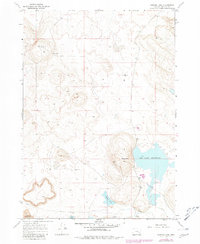
1967 Map of Barton Lake
USGS Topo · Published 1980About this map
Dry Lake Reservoir and the volcanic landscape of Diamond Craters dominate this Harney County quadrangle, surveyed in 1967 and updated with 1979 photorevisions. The map documents a sparsely settled high-desert environment where water management is central to the land's utility, evidenced by the presence of Barton Ranch and a network of essential water sources including Voltage Well, Beckley Well, and Barton Lake Well. The drainage patterns are clearly defined by Riddle Creek feeding into the local basin, while the eponymous Barton Lake and nearby White Lake sit in the shadow of prominent ridgelines. The transition between the 1960s field data and 1980 publication shows the persistence of these remote ranching outposts and their reliance on these isolated watering points.
Find a feature on this map
10 named features on this map. Tap any name to fly to it.
Don’t see what you’re looking for? This feature index may not catch every label — zoom into the map to look around manually.
Map Details
Editions of this 1967 Barton Lake Map
2 editions found
Other maps of this area

1955 · Burns
USGS Topo · 1:250,000

1958 · Burns
USGS Topo · 1:250,000

1959 · Burns
USGS Topo · 1:250,000

1959 · Lawen
USGS Topo · 1:62,500

1960 · Crane
USGS Topo · 1:62,500

1967 · Happy Valley
USGS Topo · 1:24,000

1967 · Jackass Butte NE
USGS Topo · 1:24,000

1967 · Barton Lake
USGS Topo · 1:24,000
1967 · Diamond Swamp
USGS Topo · 1:24,000

1967 · Diamond
USGS Topo · 1:24,000