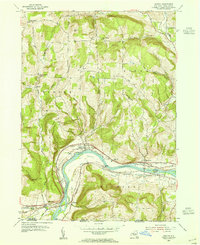
1953 Map of Barton
USGS Topo · Published 1955About this map
The Susquehanna River carves a sweeping path through the Southern Tier, defining the industrial and agricultural landscape of this New York-Pennsylvania border region. In the early 1950s, the river valley served as a critical transportation corridor, hosting three major rail lines: the Lehigh Valley RR, the Erie RR, and the Delaware Lackawanna and Western RR. These lines bracket the settlements of Barton and Smithboro, while the village of Nichols sits just south of the river bend.
Find a feature on this map
45 named features on this map. Tap any name to fly to it.
Don’t see what you’re looking for? This feature index may not catch every label — zoom into the map to look around manually.
Map Details
Editions of this 1953 Barton Map
This is the sole edition of this map. No revisions or reprints were ever made.
Other maps of this area

1902 · Waverly
USGS Topo · 1:62,500

1903 · Owego
USGS Topo · 1:62,500

1905 · Watkins Glen
USGS Topo · 1:125,000

1906 · Catatonk
USGS Topo · 1:125,000

1923 · Towanda
USGS Topo · 1:62,500

1926 · Towanda
USGS Topo · 1:62,500

1939 · Sayre
USGS Topo · 1:62,500

1942 · Sayre
USGS Topo · 1:62,500

1943 · Towanda
USGS Topo · 1:62,500

1948 · Sayre
USGS Topo · 1:62,500