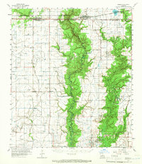
1960 Map of Basile
USGS Topo · Published 1966About this map
The town of Basile sits at the convergence of several Louisiana parishes, marking a landscape defined by its transition from prairie to wetlands. In the early 1960s, this region was a critical node for both agricultural and energy interests. The map documents the extensive development of natural resources, featuring the North Tepetate Oil and Gas Field and the Evangeline Oil and Gas Field. These industrial zones are interspersed with established rural communities like Iota, Elton, and Hathaway, where local life centered around institutions such as St Monica Ch and Miller Ch.
Find a feature on this map
58 named features on this map. Tap any name to fly to it.
Don’t see what you’re looking for? This feature index may not catch every label — zoom into the map to look around manually.
Map Details
Editions of this 1960 Basile Map
4 editions found
Other maps of this area

1946 · Mermentau
USGS Topo · 1:31,680

1946 · Jennings
USGS Topo · 1:31,680

1947 · Evangeline
USGS Topo · 1:31,680

1947 · Kinder
USGS Topo · 1:31,680

1947 · Fruge Lake
USGS Topo · 1:31,680

1947 · Oberlin
USGS Topo · 1:31,680

1947 · Pine Island
USGS Topo · 1:31,680

1947 · Welsh
USGS Topo · 1:31,680

1947 · Redland
USGS Topo · 1:31,680

1947 · Elton
USGS Topo · 1:31,680