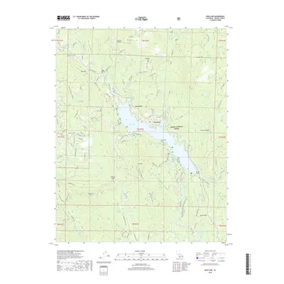
2018 Map of Bass Lake
USGS Topo · Published 2018About this map
Bass Lake serves as the central focal point of this Sierra Nevada landscape, surrounded by the developed settlement of The Pines and numerous recreational and utility features. The shoreline is well-defined by numerous coves, including Willow Cove and Wishon Cove, which hint at the region's importance for local recreation and water management. High-elevation landmarks such as Goat Mtn L O and the Goat Mtn Electronics Site overlook the basin, while the Fish Hatchery near the northern shore indicates active resource management. The map details a complex network of forest roads and trails, such as the Cowboy Trail and Emergency Fire Rd, which navigate the terrain between Taylor Mtn and Thornberry Mtn. Local industry and land use are reflected in features like the Hole Ranch and the Browns Cr Ditch, showing the intersection of ranching and water infrastructure within the Sierra National Forest.
Find a feature on this map
117 named features on this map. Tap any name to fly to it.
Don’t see what you’re looking for? This feature index may not catch every label — zoom into the map to look around manually.
Map Details
Editions of this 2018 Bass Lake Map
This is the sole edition of this map. No revisions or reprints were ever made.
Other maps of this area

1904 · Kaiser
USGS Topo · 1:125,000

1912 · Mariposa
USGS Topo · 1:125,000

1942 · Millerton Lake
USGS Topo · 1:62,500

1945 · Millerton Lake
USGS Topo · 1:62,500

1947 · Mariposa
USGS Topo · 1:250,000

1948 · Mariposa
USGS Topo · 1:250,000
1953 · Bass Lake
USGS Topo · 1:62,500

1953 · Shaver Lake
USGS Topo · 1:62,500

1953 · Shuteye Peak
USGS Topo · 1:62,500

1957 · Mariposa
USGS Topo · 1:250,000