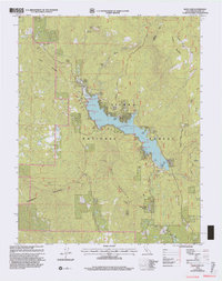
1993 Map of Bass Lake
USGS Topo · Published 2002About this map
Crane Valley serves as the topographic centerpiece of this Sierra Nevada landscape, dominated by the waters of Bass Lake. By the early 1990s, the shoreline supported a series of established communities and recreation points, including The Pines, The Falls, and Bass Lake Annex. The local social fabric is anchored by landmarks like the Bass Lake Sch, the Denver Church, and the Little Denver Church, while industrial utility is evidenced by the Powerhouse and multiple gaging stations. Beyond the water, the terrain rises sharply toward Goat Mountain, topped by the Goat Mountain Lookout. This survey documents a sophisticated mountain infrastructure where Beasore Road and Central Camp Road provide access to higher elevations like Chepo Saddle and McLeod Flat, reflecting the area's development for both resource management and seasonal habitation.
Find a feature on this map
53 named features on this map. Tap any name to fly to it.
Don’t see what you’re looking for? This feature index may not catch every label — zoom into the map to look around manually.
Map Details
Editions of this 1993 Bass Lake Map
This is the sole edition of this map. No revisions or reprints were ever made.
Other maps of this area

1904 · Kaiser
USGS Topo · 1:125,000

1912 · Mariposa
USGS Topo · 1:125,000

1942 · Millerton Lake
USGS Topo · 1:62,500

1945 · Millerton Lake
USGS Topo · 1:62,500

1947 · Mariposa
USGS Topo · 1:250,000

1948 · Mariposa
USGS Topo · 1:250,000
1953 · Bass Lake
USGS Topo · 1:62,500

1953 · Shaver Lake
USGS Topo · 1:62,500

1953 · Shuteye Peak
USGS Topo · 1:62,500

1957 · Mariposa
USGS Topo · 1:250,000