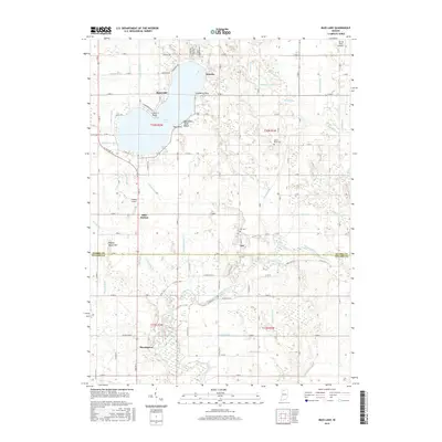
2016 Map of Bass Lake
USGS Topo · Published 2016About this map
Bass Lake dominates the northern half of this landscape, its shoreline defined by Winona, Cranberry Point, and Bass Lake State Beach. The surrounding terrain is heavily influenced by a complex network of agricultural drainage, including the Craigmile Ditch and Marks Ditch. To the south, the Tippecanoe River meanders through the boundary between Starke and Pulaski counties, passing near the small settlements of Ora and Beardstown. This survey captures a transitional area where lake-front recreation meets a managed river valley. Genealogists may find value in the locations of the North Bend Cem and Ora Cem, while aviation history is represented by Wheeler Airport and the Van de Mark Airport further north. The map also traces the local road system, from S State Rd 10 to the grid of rural county roads like Co Rd W 600 N that cross the river bottoms.
Find a feature on this map
76 named features on this map. Tap any name to fly to it.
Don’t see what you’re looking for? This feature index may not catch every label — zoom into the map to look around manually.
Map Details
Editions of this 2016 Bass Lake Map
This is the sole edition of this map. No revisions or reprints were ever made.
Other maps of this area

1953 · Chicago
USGS Topo · 1:250,000

1957 · Chicago
USGS Topo · 1:250,000

1957 · Knox East
USGS Topo · 1:24,000

1957 · Knox West
USGS Topo · 1:24,000

1958 · Donaldson
USGS Topo · 1:24,000

1962 · Winamac
USGS Topo · 1:24,000

1962 · Kewanna
USGS Topo · 1:24,000

1962 · Denham
USGS Topo · 1:24,000
1962 · Ripley
USGS Topo · 1:24,000

1962 · Bass Lake
USGS Topo · 1:24,000