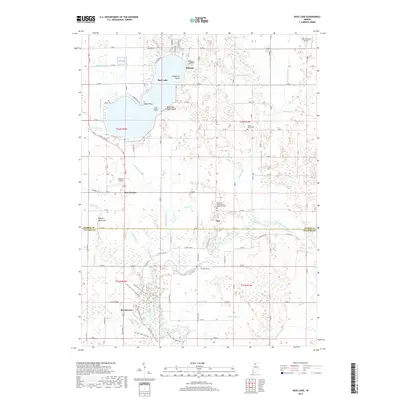
2019 Map of Bass Lake
USGS Topo · Published 2019About this map
Bass Lake and its surrounding wetlands anchor this recent survey of the boundary between Starke and Pulaski Counties. The shoreline is densely developed with residential roads such as E Manor Dr and E Woodland Dr, contrasting with the recreational grounds of Bass Lake State Beach at Gull Point. To the south, the Tippecanoe River meanders through a landscape defined by an extensive network of drainage infrastructure, including Castleman Ditch and Griner Ditch. Small settlements like Beardstown and Ora serve as local hubs for the surrounding agricultural tracts. Notable landmarks such as Pigeon Roost Hill and local airfields like Wheeler Airport provide fixed points of interest in a region historically shaped by its proximity to water and the conversion of marshlands into productive farmland.
Find a feature on this map
74 named features on this map. Tap any name to fly to it.
Don’t see what you’re looking for? This feature index may not catch every label — zoom into the map to look around manually.
Map Details
Editions of this 2019 Bass Lake Map
This is the sole edition of this map. No revisions or reprints were ever made.
Other maps of this area

1953 · Chicago
USGS Topo · 1:250,000

1957 · Chicago
USGS Topo · 1:250,000

1957 · Knox East
USGS Topo · 1:24,000

1957 · Knox West
USGS Topo · 1:24,000

1958 · Donaldson
USGS Topo · 1:24,000

1962 · Winamac
USGS Topo · 1:24,000

1962 · Kewanna
USGS Topo · 1:24,000

1962 · Denham
USGS Topo · 1:24,000
1962 · Ripley
USGS Topo · 1:24,000

1962 · Bass Lake
USGS Topo · 1:24,000