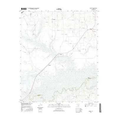
2016 Map of Bassett
USGS Topo · Published 2016About this map
The Sulphur River carves a complex course through this Bowie and Cass County borderland, defining a landscape dominated by expansive bottomlands and numerous oxbow features. The low-lying terrain is marked by distinct water bodies including Calver Lake, Mudd Lake, Blue Lake, and Thomas Lake, which together illustrate the shifting hydrology of the river basin. To the northeast, Wright Patman Lake begins to influence the drainage patterns of local tributaries like Bassett Cr and Brooks Cr.
Find a feature on this map
67 named features on this map. Tap any name to fly to it.
Don’t see what you’re looking for? This feature index may not catch every label — zoom into the map to look around manually.
Map Details
Editions of this 2016 Bassett Map
This is the sole edition of this map. No revisions or reprints were ever made.
Other maps of this area

1909 · New Boston
USGS Topo · 1:62,500

1910 · Linden
USGS Topo · 1:62,500

1914 · Daingerfield
USGS Topo · 1:62,500

1930 · Bassett
USGS Topo · 1:62,500

1953 · Texarkana
USGS Topo · 1:250,000

1954 · New Boston
USGS Topo · 1:24,000

1955 · Corley
USGS Topo · 1:24,000

1955 · New Boston
USGS Topo · 1:62,500

1956 · Texarkana
USGS Topo · 1:250,000
1965 · Hodgson
USGS Topo · 1:24,000